
Building Information Modeling (BIM) has revolutionized the architecture, engineering, and construction (AEC) industry, offering a comprehensive approach to managing a building’s lifecycle. From initial design and construction to ongoing operations and maintenance, BIM integrates geometric data with a wealth of information, including material specifications, spatial dimensions, and system components. This rich database serves as a robust foundation for informed decision-making, fostering enhanced coordination and efficiency among all stakeholders involved in a project.
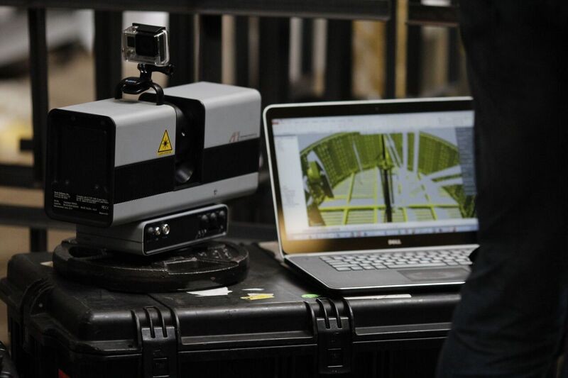
Within the BIM ecosystem, 3d Laser Scanning Tools and the process of “Scan to BIM” are becoming increasingly vital. As BIM adoption expands across industries and regulatory requirements become more stringent, especially for updating and retrofitting existing structures, the need for accurate digital representations of real-world conditions is paramount. Often, existing buildings lack comprehensive digital models, creating a significant gap in the BIM workflow. Scan to BIM bridges this gap, enabling the creation of precise BIM models from 3D scans of existing buildings, significantly improving planning accuracy, project coordination, and cost management.
This article explores the diverse landscape of 3D laser scanning tools utilized in Scan-to-BIM projects. We will delve into different types of scanners, examining their capabilities, applications, and how they contribute to creating detailed and accurate BIM models.
Understanding Scan to BIM: Bridging the Digital Divide
Scan to BIM represents a cutting-edge workflow within the AEC sector. It leverages advanced 3D laser scanning tools to digitally capture existing buildings and transform them into intelligent BIM models. This process allows for the precise documentation of existing structures, aligning them with modern planning and documentation methodologies. By accurately capturing the as-built environment, Scan to BIM streamlines workflows, saves valuable time, and enhances collaboration throughout a building’s entire lifecycle.
3D laser scanning tools, ranging from mobile LiDAR systems to high-precision terrestrial scanners, are at the heart of this process. These tools capture detailed spatial data from existing buildings, generating dense point clouds that serve as the foundational dataset for BIM model creation. This point cloud accurately represents the geometry of the scanned environment, providing a true digital twin of the physical structure.
Terrestrial 3D Laser Scanners: Capturing Precision and Detail
Terrestrial laser scanners, also known as static laser scanners, stand as the gold standard in 3D laser scanning tools, particularly when high accuracy and detailed data are required. These sophisticated devices are indispensable in the surveying and construction industries, known for their ability to digitize complex environments with remarkable precision and detail.
Typically mounted on tripods, terrestrial scanners operate by emitting laser beams that rotate to capture vast areas from fixed positions. This systematic approach results in highly accurate point clouds, which are essential for creating detailed BIM models, precise CAD drawings, and various applications demanding accurate dimensions and comprehensive documentation of physical spaces.
API HemiScan
Image Alt Text: API HemiScan 3D laser scanning tool for industrial BIM applications.
Source: https://apimetrology.com/hemiscan/
Max. Reach: 70 m
Scan Rate: 1.2 million points/second
Price: On request
The API HemiScan is a robust 3D laser scanning tool engineered for demanding industrial and outdoor BIM projects. Boasting a rapid scan rate of 1.2 million points per second and a range of up to 70 meters, this spherical scanner delivers exceptionally accurate measurements. With an impressive resolution of 0.001 mm, it facilitates the creation of high-resolution 3D CAD models, ideal for intricate BIM applications.
The HemiScan’s versatility extends to data export compatibility with leading software platforms such as PolyWorks®, RapidForm®, Geomagic®, Cyclone®, and RealWorks®. Its rugged design and high mobility make it well-suited for challenging scanning environments where precision and reliability are paramount for BIM data acquisition.
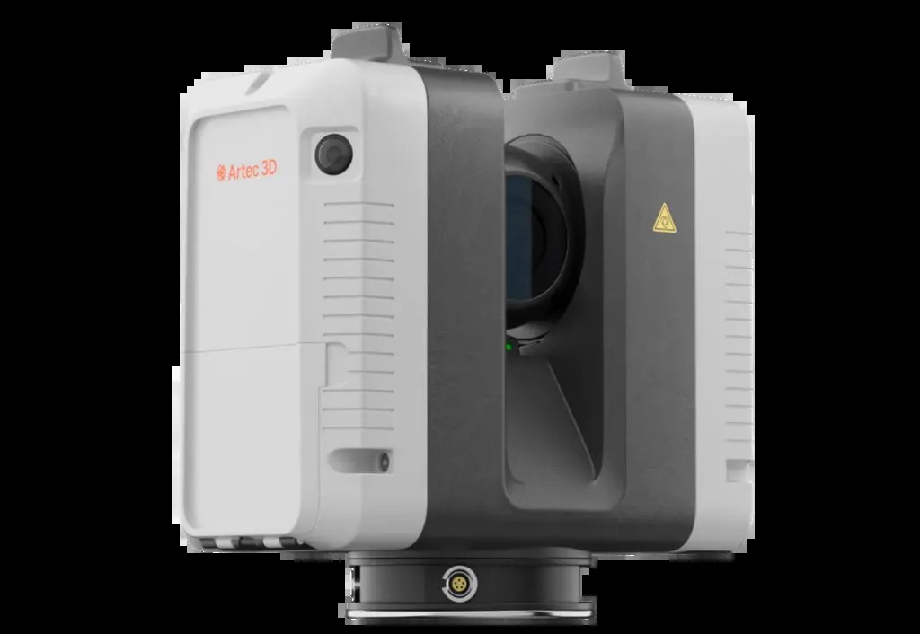
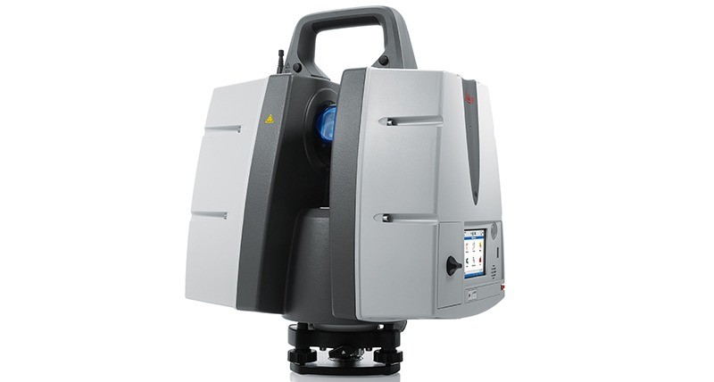
Artec Ray II
Image Alt Text: Artec Ray II terrestrial 3D laser scanner for BIM modeling and construction.
Source: https://www.artec3d.com/portable-3d-scanners/laser-ray
Max. Reach: 0.5-130 m
Scan Rate: 2 million points/second
Price: ~ €60,000
The Artec Ray II stands out as a high-performance terrestrial 3D laser scanning tool with an extended range of 130 meters and impressive accuracy, achieving less than 1.9 mm deviation at a 10-meter distance. It rapidly generates dense and detailed point clouds in just 1.7 minutes, equipped with three internal cameras offering a 36-megapixel resolution for capturing rich visual data alongside geometric information for BIM models. Powered by rechargeable batteries providing up to four hours of operation, the Ray II offers flexibility for both indoor and outdoor BIM scanning projects.
Furthermore, the Artec Ray II seamlessly integrates with handheld scanners like the ARTEC Eva, Spider, or Leo, enabling comprehensive data capture even in confined or hard-to-reach areas. Data processing is efficiently handled by the powerful ARTEC Studio software, allowing users to refine scan results and export them for reverse engineering applications within programs like Geomagic Design X, SolidWorks, or ReCap, streamlining the Scan to BIM workflow.
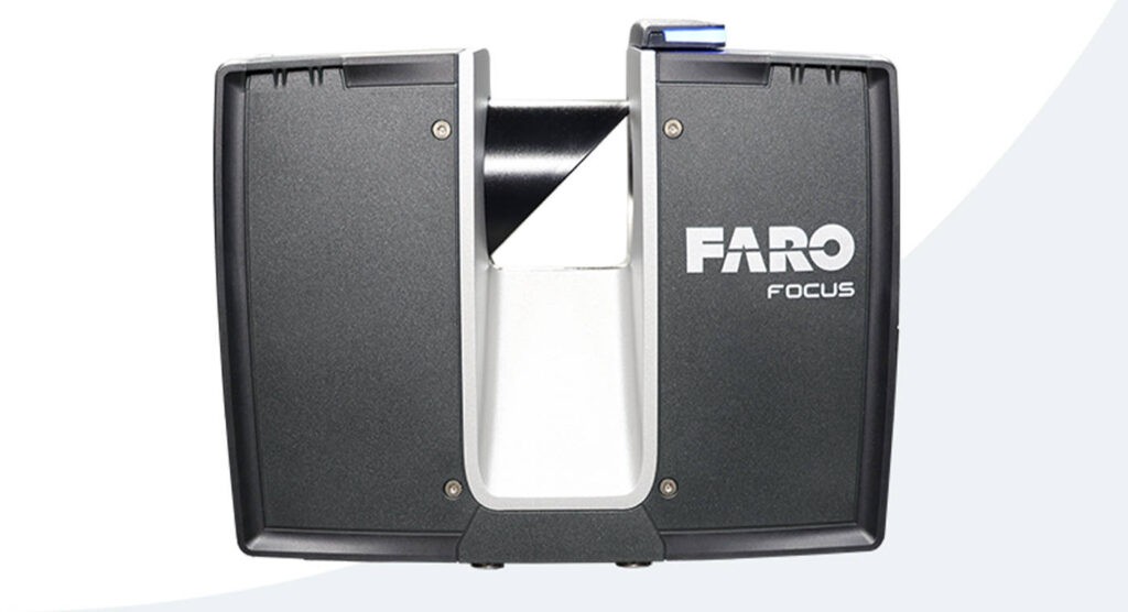
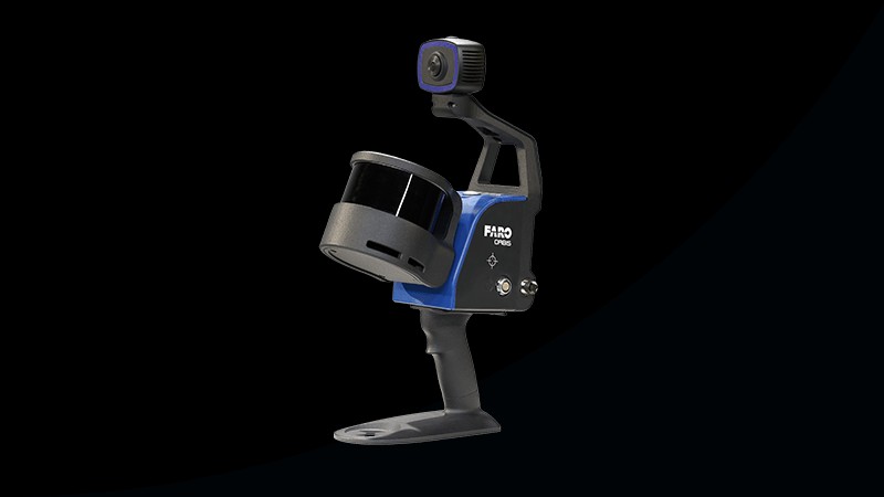
FARO Focus Premium
Image Alt Text: FARO Focus Premium high-speed 3D laser scanner for BIM and facility management.
Source: https://www.faro.com/en/Resource-Library/Brochure/FARO-Focus-Premium
Max. Reach: 70 m (expandable to 350 m)
Scan Rate: 2 million points/second
Price: ~ €40,200
The FARO Focus Premium is a high-efficiency 3D laser scanning tool designed for rapid data capture in BIM projects. It can complete a scan in approximately one minute, depending on settings. Combining a range of 70m, expandable to 350m with an optional extension, and a scanning speed of up to two million points per second, the Focus Premium prioritizes speed and efficiency in data acquisition for BIM workflows.
Beyond rapid scanning, the FARO Focus Premium streamlines data processing and team collaboration. Scanner control and initial data processing can be performed via the FARO Stream app for Android and iOS devices, while final data registration is handled through FARO Scene software, minimizing the need for extensive office-based processing and accelerating the Scan to BIM process.
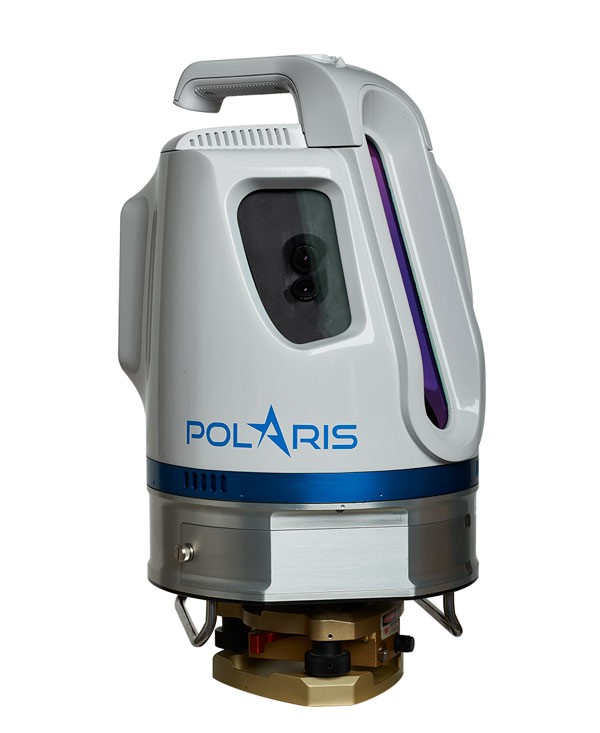
Teledyne Optech Polaris
Image Alt Text: Teledyne Optech Polaris long-range 3D laser scanner for BIM and infrastructure projects.
Source: https://www.teledyneoptech.com/
Max. Reach: 2,000 m
Scan Rate: 1 million points/second
Price: On request
The Teledyne Optech Polaris is a versatile terrestrial 3D laser scanning tool known for its extensive range and reliability across diverse applications, including construction, mining, and forestry BIM projects. It delivers highly accurate data even in challenging environmental conditions thanks to its robust, weatherproof housing. The Polaris can be deployed on a tripod, platform, or vehicle, offering adaptable deployment options for varied BIM project requirements.
The Polaris boasts a wide and customizable field of view, enabling users to capture large areas efficiently or focus on specific details. With a maximum range of 2,000 meters, a resolution of 2mm within its measurement range, and an accuracy of 5mm up to 100 meters, it is well-suited for large-scale BIM projects requiring long-range scanning capabilities.
Leica ScanStation P50
Image Alt Text: Leica ScanStation P50 high-performance 3D laser scanner for BIM in demanding environments.
Source: https://leica-geosystems.com/
Max. Reach: > 1 km
Scan Rate: 1 million points/second
Price: ~ €35,000
The Leica ScanStation P50 represents a powerful 3D laser scanning tool solution for BIM professionals needing to survey inaccessible locations safely and efficiently from a distance. Its exceptional range and ability to capture high-quality 3D data and HDR imagery make it ideal for documenting large and challenging infrastructure or open-pit mining sites for BIM applications.
In addition to its high performance and reliability in extreme conditions (-20°C to +50°C, IP54 rating for dust and water protection), the ScanStation P50 offers a comprehensive scanning solution. Data processing is powered by Leica’s industry-leading 3D point cloud software suite, including Leica Cyclone, JetStream, CloudWorx, and the free Leica TruView. Tight integration with the Cyclone FIELD 360 app ensures a seamless workflow from field data acquisition to final data registration in the office, enhancing the efficiency of Scan to BIM projects.
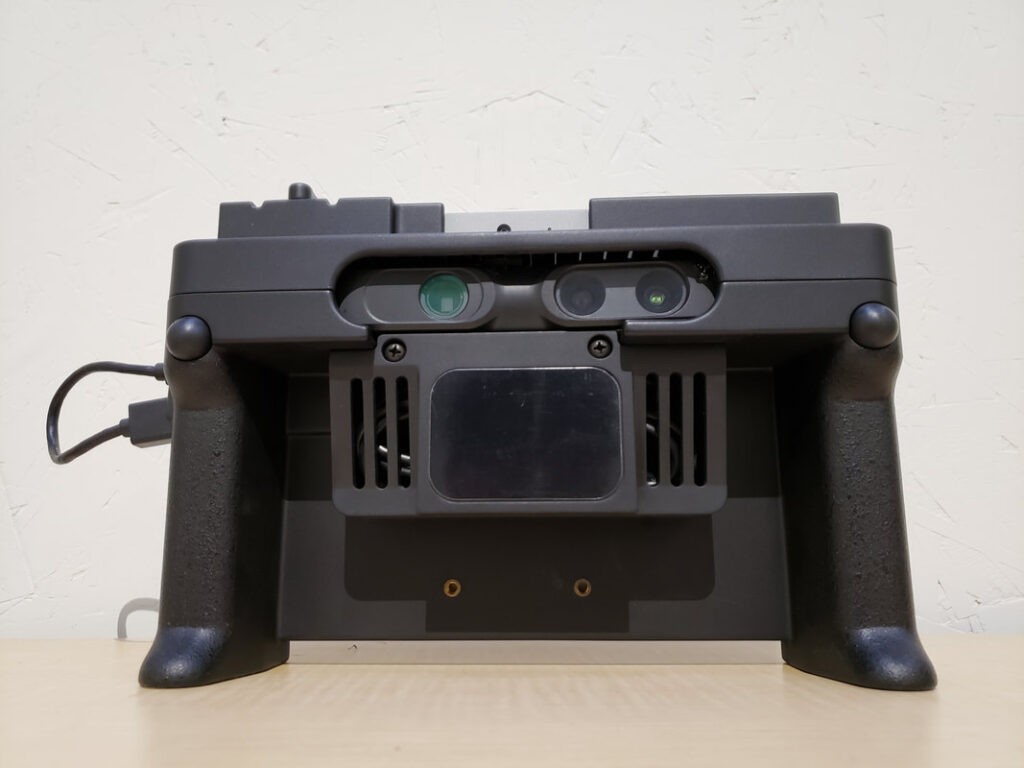
Handheld 3D Laser Scanners: Portability and Flexibility in Tight Spaces
Handheld scanners offer a compact and portable approach to 3D laser scanning tools, designed for capturing three-dimensional data from objects and environments with greater flexibility. These devices are particularly advantageous for collecting data in complex or confined areas where tripod-mounted scanners may be impractical. Handheld scanners are ideal for rapid, efficient scanning of smaller, detailed objects and often provide immediate visualization and editing capabilities for captured data, making them valuable for on-site BIM workflows.
Dotproduct DPI-10 KIT
Image Alt Text: Dotproduct DPI-10 KIT handheld 3D scanner for real-time BIM data capture.
Source: https://www.dotproduct3d.com/dpi10.html
Max. Reach: 0.6-3.7 m
Scan Rate: Real-time detection
Price: ~ €3,600
The DotProduct DPI-10 Kit is an advanced handheld 3D laser scanning tool system capable of capturing objects and environments in real time for BIM applications. Powered by a PrimeSense Carmine 1.08 camera and Dot3D™ software, this system transforms a Samsung Galaxy S6 or Windows Go tablet into a user-friendly handheld scanner.
Data processing and registration occur directly on the tablet, enabling users to define coordinate systems, register multiple datasets on-site, and take measurements instantly. Dot3D™ software utilizes advanced Simultaneous Localization and Mapping (SLAM) algorithms to deliver real-time 3D reconstructions and localizations directly to the mobile device, facilitating immediate feedback and efficient BIM data collection.
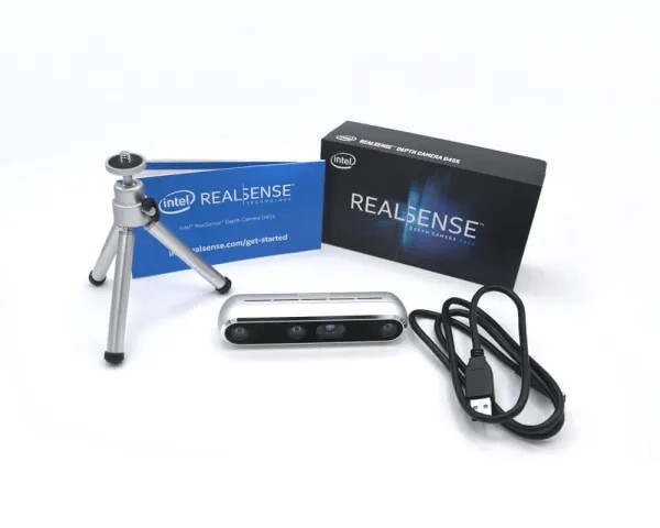
Intel RealSense D455 KIT
Image Alt Text: Intel RealSense D455 KIT affordable handheld 3D scanner for BIM and prototyping.
Source: https://store.intelrealsense.com/
Max. Reach: 0.4-4.2 m
Scan Rate: Up to 90 fps
Price: ~ €1,900
The Intel® RealSense™ D455 kit represents the latest advancement in the D400 series, incorporating over a decade of stereo camera expertise and customer feedback. This handheld 3D laser scanning tool features LiDAR technology alongside an integrated RGB camera and an IMU, enabling precise 3D data capture within a range of 0.4 to 4.2 meters for BIM and other 3D applications.
The kit is complemented by Dot3D™ Pro software, leveraging sophisticated SLAM algorithms to support real-time point cloud acquisition, processing, and reconstruction on mobile devices. This combination provides a cost-effective and accessible entry point into handheld 3D scanning for BIM professionals.
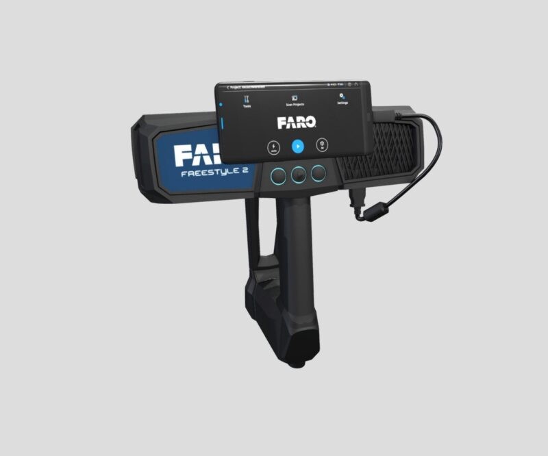
FARO Freestyle 2.5
Image Alt Text: FARO Freestyle 2.5 handheld color 3D scanner for intuitive BIM data capture.
Source: https://www.faro.com/
Max. Reach: 0.4-10 m
Scan Rate: 220,000 points/second
Price: On request
The FARO Freestyle 2.5 is a handheld 3D laser scanning tool specifically designed for rapid and photorealistic 3D data capture with real-time visualization. With a range of 0.4 to 10 meters, the Freestyle 2.5 offers intuitive scanning without requiring external hardware, as all data is visualized directly on the device during capture, streamlining BIM data acquisition workflows.
This scanner delivers high-quality, color 3D data with an accuracy of up to 0.5 mm. Haptic feedback informs the user about scan quality, and scan data quality is displayed live on the device. Data processing is enhanced by advanced tracking algorithms enabling natural scanning movements and seamless integration with professional software like FARO Scene for further analysis and BIM model creation.
Mobile 3D Laser Scanners: Speed and Coverage for Large-Scale BIM Projects
Mobile laser scanners are designed to capture environmental data while in motion, such as walking through a building or driving around a site. These 3D laser scanning tools are often more complex systems, comprising a measuring head, multiple laser scanners, and various cameras, including panoramic options. To maintain positional awareness, sophisticated mobile scanners incorporate GPS antennas and Inertial Measurement Units (IMUs). This technology enables rapid data acquisition for large-scale BIM projects, especially in environments where static scanning is time-consuming or impractical.
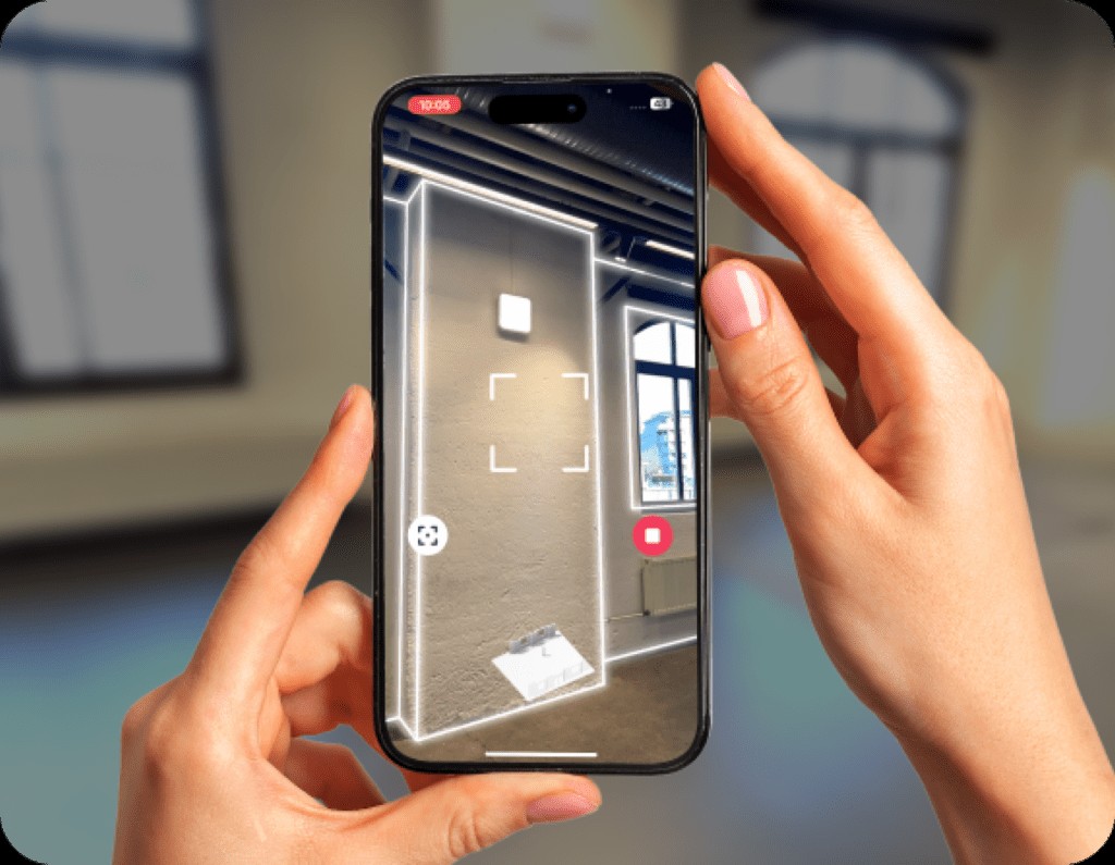
Metaroom® Scan App
Image Alt Text: Metaroom Scan App mobile 3D scanning tool for Apple Pro devices in BIM.
Source: https://amrax.ai/
Max. Reach: 5 m
Scan Rate: Real-time detection
Metaroom® Scan app: Free
Metaroom® Studio Price: From €79/month
The Metaroom® Scan app is a cutting-edge mobile 3D laser scanning tool designed for Apple Pro devices. It leverages the device’s LiDAR sensor to scan interiors and generate detailed, accurate 3D models of rooms for BIM applications. The LiDAR sensor is crucial for capturing spatial dimensions during the scanning process. The app also employs AI-driven object recognition to enhance the accuracy and detail level of digital models, simplifying the scanning process and empowering professionals to create precise 3D BIM models.
Using the Metaroom® Scan app, users can create comprehensive 3D BIM models of entire buildings by scanning room by room. This method allows for detailed capture of all building levels, with individual scans automatically stitched together into a cohesive 3D model. The app provides clear guidance throughout the process, ensuring all building sections are thoroughly documented for BIM purposes. During scanning, users can mark important areas and features, such as connections and safety equipment, which are then precisely located within the BIM model. Once scans are complete, data is uploaded to the cloud for processing, generating a CAD-ready 3D model that can be enriched with further information in Metaroom® Studio and exported in various formats for seamless integration with BIM and CAD software, streamlining the entire Scan to BIM workflow from data capture to planning.
FARO Orbis
Image Alt Text: FARO Orbis mobile SLAM 3D laser scanner for rapid BIM data acquisition.
Source: https://www.faro.com/
Max. Reach: 120 m
Scan Rate: 640,000 points/second
Price: ~ €47,000
The FARO Orbis combines the advantages of terrestrial laser scanning with mobile SLAM technology, resulting in a powerful mobile 3D laser scanning tool for BIM projects. This innovative combination enables data acquisition up to ten times faster than traditional static scanning methods, significantly reducing project timelines.
With a maximum range of 120 meters and a capture rate of 640,000 points per second, the Orbis delivers both the speed of SLAM and the high accuracy associated with terrestrial scanning, thanks to integrated FARO Flash technology. This hybrid approach makes it ideal for large-scale BIM projects requiring rapid and accurate data capture.
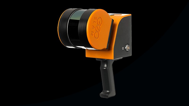
ZEB Horizon
Image Alt Text: ZEB Horizon mobile 3D laser scanner for indoor and outdoor BIM surveying.
Source: https://www.faro.com/
Max. Reach: 100 m
Scan Rate: 300,000 points/second
Price: On request
The ZEB Horizon and ZEB Horizon RT represent the latest mobile 3D laser scanning tools from GeoSLAM, designed for both outdoor and indoor BIM applications. With a range of up to 100 meters, these devices are well-suited for data collection in expansive open areas as well as GPS-denied environments, offering versatility across diverse BIM project settings.
Operation of the ZEB Horizon is intuitive, and data processing can be performed directly on-site, providing flexible usage options, including deployment on drones, vehicles, or handheld operation. The scanner captures 300,000 points per second with an accuracy of up to 6 mm and includes GeoSLAM Connect and GeoSLAM Draw software for automatic registration and rapid scan data evaluation, streamlining the mobile Scan to BIM workflow.
| Scanner | Max. Reach | Scan Rate (points/second) | Price | Special Features |
|---|---|---|---|---|
| FARO Focus Premium | up to 350 m | up to 2 Mio. | €40,200 | High-Speed-SSD, robust, GeoSLAM-Technology |
| TELEDYNE OPTECH POLARIS | up to 2,000 m | 1 Mio. | Unknown | Suitable for GPS-poor environments |
| ARTEC Ray II | up to 130 m | up to 1,2 Mio. | €60,000 | Portable, lightweight, high-resolution 3D CAD models possible |
| DotProduct DPI-10 Kit | 0.6 – 3.7 m | Real-time | €3,600 | Handheld, for small and hard-to-reach areas |
| Intel® RealSense™ D455 Kit | 0.4 – 4.2 m | up to 90 fps | €1,900 | Integrated RGB camera, LiDAR, supports various formats |
| FARO Freestyle 2.5 | 0.4 – 10 m | 220,000 | Unknown | Portable, lightweight, suitable for indoor and outdoor use |
| ZEB Horizon / ZEB Horizon RT | up to 100 m | 300,000 | Uknown | Real-time feedback, lightweight, suitable for UAVs |
| FARO Orbis | up to 120 m | 640,000 | €47,000 | Hybrid of terrestrial and mobile scanning |
| Leica ScanStation P50 | more than 1 km | 1 Mio. | €35,000 | Extremely robust, for long distances |
| Metaroom® Solution | 10 m | Real-time | from €79/month | Cost-effective, no expert knowledge required, uses Apple Pro devices, no additional devices required, many export formats, no additional software required |
| FARO Focus S70 | up to 70 m | 976,000 | Unknown | Accurate, fast, for precise measurements and documentation |
Feature overview of 3D scanners for BIM.
Conclusion: Embracing 3D Laser Scanning Tools for Enhanced BIM Workflows
3D laser scanning tools have fundamentally transformed the application of Building Information Modeling (BIM). These technologies, central to the “Scan to BIM” process, empower professionals to accurately capture existing building structures, providing essential data for construction planning, renovation projects, and ongoing maintenance. This capability is particularly invaluable when working with buildings lacking existing digital models. By enabling the creation of precise planning foundations, 3D laser scanning tools significantly improve project coordination and cost management within BIM workflows.
While many high-performance 3D laser scanning tools, particularly terrestrial scanners, represent a significant investment and are often employed by specialized surveying professionals, mobile laser scanners offer a more accessible and versatile alternative. The Metaroom system, distinguished by its user-friendliness and flexibility, stands out in the mobile scanning category. By leveraging standard Apple Pro devices, Metaroom enables users to create detailed 3D BIM models by systematically scanning room by room, eliminating the need for expensive, specialized hardware.
In conclusion, modern 3D laser scanning tools are an indispensable asset for advancing Building Information Modeling. They not only simplify and accelerate the data capture process but also optimize subsequent planning and construction phases. These technological advancements enhance accuracy, expand the capabilities of BIM, and ultimately contribute to more efficient and cost-effective construction and renovation projects. The continued evolution of 3D laser scanning tools promises even greater integration and impact within the BIM landscape, driving further innovation and efficiency in the AEC industry.